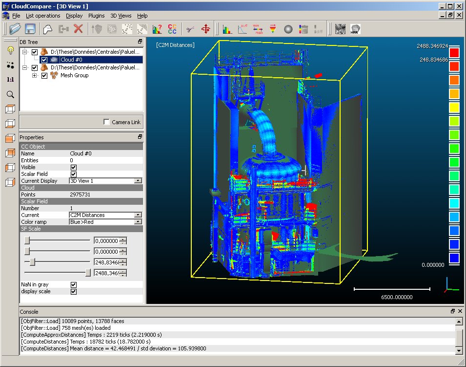
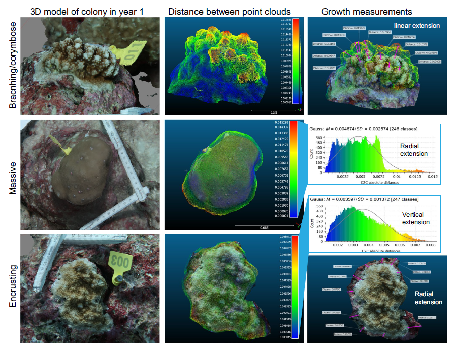
CloudCompare is a powerful and versatile open-source software application designed for the processing, visualization, and analysis of 3D point clouds. This comprehensive tool empowers users to explore, manipulate, and extract meaningful insights from complex 3D data, opening up a world of possibilities in fields like engineering, architecture, archaeology, and more.
Table of Contents
At its core, CloudCompare enables users to import, clean, and analyze point cloud data derived from various sources, including laser scanners, aerial imagery, and 3D models. Its intuitive interface and extensive features make it an ideal choice for professionals and researchers seeking to work with large and intricate 3D datasets.
3D Visualization and Analysis: Cloudcompare

CloudCompare is a powerful and versatile software application designed for visualizing and analyzing 3D point clouds. Its user-friendly interface and extensive feature set make it a popular choice for professionals in various fields, including geomatics, architecture, and engineering.
Point Cloud Visualization, Cloudcompare
CloudCompare offers a comprehensive set of tools for visualizing and exploring 3D point clouds. Users can adjust various visualization parameters, such as point size, color, and transparency, to highlight specific features or patterns within the data. The software also supports different point cloud formats, ensuring compatibility with various data sources.
- Color Mapping: CloudCompare allows users to map different properties to point colors, such as elevation, intensity, or classification values. This enables visual analysis of spatial patterns and data variations within the point cloud. For example, a color gradient can be applied to represent elevation changes, highlighting topographic features like hills and valleys.
- Point Cloud Filtering: CloudCompare provides a range of filtering options to remove noise, outliers, or unwanted points from the point cloud. This process enhances the visual clarity and accuracy of the data.
- Cross-Sections and Profiles: The software enables users to generate cross-sections and profiles through the point cloud, providing insights into the internal structure and geometry of the object or environment.
- 3D Model Rendering: CloudCompare can render 3D models from point clouds, enabling users to visualize the data in a more realistic and interactive way.
Measurement and Analysis
CloudCompare provides a suite of tools for performing various measurements and analyses on 3D point clouds. This includes:
- Distance Measurement: Users can measure distances between points, lines, and surfaces within the point cloud, enabling accurate spatial analysis.
- Area and Volume Calculation: CloudCompare can calculate the area of surfaces and the volume of enclosed spaces within the point cloud. This is particularly useful for applications such as volume estimation in mining or construction.
- Feature Extraction: CloudCompare allows users to identify and extract specific features from point clouds, such as edges, corners, and planes. This can be helpful for analyzing building structures or identifying geological features.
- Point Cloud Registration: CloudCompare provides tools for registering multiple point clouds, aligning them in a common coordinate system. This is essential for creating a complete and accurate representation of a large-scale environment.
Integration with Other Tools

CloudCompare is a powerful tool for 3D point cloud processing, but its capabilities can be further enhanced by integrating it with other software and tools. This integration allows for more comprehensive data analysis, visualization, and workflow optimization.
Integration with GIS Software
Integrating CloudCompare with GIS software, such as QGIS or ArcGIS, allows for seamless integration of point cloud data with geographic information systems. This enables users to:
- Geo-reference point clouds: By aligning point clouds with geographic coordinates, they can be accurately positioned within a geographic context. This allows for spatial analysis and integration with other geospatial data.
- Overlay point clouds with maps and other spatial data: This integration enables users to visualize and analyze point cloud data in relation to other geographic features, such as roads, buildings, and water bodies. This allows for context-aware analysis and interpretation of the data.
- Perform spatial analysis: By combining point cloud data with GIS tools, users can perform various spatial analyses, such as proximity analysis, buffer creation, and area calculations. This provides valuable insights into the spatial characteristics of the point cloud data.
Integration with CAD Programs
Integrating CloudCompare with CAD programs, such as AutoCAD or Revit, enables the import and export of point cloud data in various formats. This allows for:
- Direct integration of point cloud data into CAD models: Point clouds can be directly imported into CAD programs as reference data, allowing for accurate modeling and design based on real-world data. This eliminates the need for manual data conversion and ensures consistency between the point cloud and the CAD model.
- Creation of 3D models from point clouds: CloudCompare can be used to generate 3D models from point clouds, which can then be imported into CAD programs for further manipulation and analysis. This allows for the creation of detailed 3D models based on real-world data, which can be used for various purposes, such as architectural design, engineering analysis, and construction planning.
- Dimensioning and measurement of point cloud data: CAD programs provide tools for precise dimensioning and measurement, which can be applied to point cloud data imported from CloudCompare. This allows for accurate analysis of the point cloud’s geometric properties and dimensions.
Integration with Image Processing Applications
CloudCompare can be integrated with image processing applications, such as ImageJ or GIMP, to leverage the capabilities of both software for advanced analysis and visualization. This allows for:
- Image-based point cloud generation: Image processing applications can be used to generate point clouds from images, which can then be imported into CloudCompare for further processing and analysis. This is particularly useful for creating 3D models from aerial or satellite imagery.
- Image-guided point cloud segmentation: By overlaying images with point clouds, users can leverage image information to segment and classify points within the cloud. This allows for more accurate and efficient point cloud segmentation based on image features.
- Visualizing point clouds with image textures: Images can be used to provide texture and color information to point clouds, creating more realistic and visually appealing 3D models. This enhances the visualization and interpretation of the point cloud data.
Advantages of Integration
Integrating CloudCompare with other tools offers several advantages:
- Enhanced data analysis: By combining the capabilities of CloudCompare with other tools, users can perform more comprehensive and insightful data analysis. This allows for a deeper understanding of the point cloud data and its relationships with other data sources.
- Workflow optimization: Integration allows for streamlined workflows, eliminating the need for manual data conversion and transferring between different software. This saves time and effort, improving efficiency and productivity.
- Increased versatility: Integrating CloudCompare with other tools expands its functionality, allowing for a wider range of applications and use cases. This makes it a more versatile and powerful tool for various industries and research areas.
Future Trends and Developments

The field of 3D point cloud processing and analysis is constantly evolving, driven by advancements in sensor technology, computing power, and the increasing demand for detailed 3D representations of the world. CloudCompare, as a powerful and versatile tool, is well-positioned to adapt and thrive in this dynamic landscape.
Integration with Deep Learning
The integration of deep learning techniques into 3D point cloud processing is a major trend that promises to revolutionize the field. Deep learning algorithms can be trained on massive datasets of point clouds to learn complex patterns and relationships, enabling them to perform tasks such as object detection, segmentation, and classification with high accuracy. CloudCompare could evolve to incorporate these capabilities, providing users with advanced tools for analyzing and interpreting point cloud data.
Deep learning-based methods can automatically extract meaningful features from point clouds, eliminating the need for manual feature engineering.
Real-Time Processing and Visualization
The demand for real-time processing and visualization of point clouds is growing rapidly, driven by applications in autonomous driving, robotics, and augmented reality. CloudCompare could evolve to support real-time processing, enabling users to interact with and analyze point cloud data in real-time. This would require optimizing algorithms and leveraging parallel computing resources to handle the high data throughput required for real-time applications.
Real-time point cloud processing allows for immediate feedback and decision-making, enabling applications like autonomous navigation and interactive 3D modeling.
Cloud-Based Platforms
Cloud-based platforms are becoming increasingly popular for 3D point cloud processing, offering advantages such as scalability, accessibility, and collaboration. CloudCompare could leverage cloud computing resources to provide users with access to powerful processing capabilities and large-scale storage solutions. This would allow users to process and analyze massive point cloud datasets without the need for expensive hardware.
Cloud-based platforms enable distributed processing and storage, making it possible to handle large-scale point cloud datasets efficiently.
Conclusive Thoughts
With its robust capabilities and user-friendly design, CloudCompare has become a cornerstone for professionals and researchers working with 3D point clouds. From visualizing intricate details to performing complex analyses, this software empowers users to unlock the hidden potential within their data. As technology continues to advance, CloudCompare’s role in shaping the future of 3D data processing and analysis is sure to grow, paving the way for groundbreaking discoveries and innovative applications across various industries.
CloudCompare is a powerful tool for analyzing and comparing 3D point clouds. It’s often used in fields like archaeology and engineering, where precise measurements are crucial. If you’re working with CAD files, you might need to convert them to a format compatible with CloudCompare.
A handy tool for this is a dwg converter , which can translate drawings into formats like OBJ or STL, making them easily accessible for CloudCompare analysis.
